A collaborative project between Washington State University, the University of Idaho, Oregon State
University, USDA, and potato industry stakeholders.
The PNW Potato DAS is a web platform designed to transfer time-sensitive information to decision makers in
the potato industry. This platform features spatial models of insect pests, allowing for better
anticipation of highly mobile pest populations. It also runs models for some pests to estimate pest
development and provide links to management and pesticide considerations.
The DAS is a comprehensive system that incorporates weather data from
WSU-AgWeatherNet
(AWN), virtual weather stations and forecasts powered by
Weather Source, historic weather data from
Daymet, and other
information sources such as the
Northwest Potato
Research Consortium. DAS attempts to
support reasonably common smart phones and tablets (iOS and Android) as well as desktop computers in all
functions. As designed, DAS also has a data/account management subsystem that simplifies use for decision
makers and allows them to tailor the information they receive.
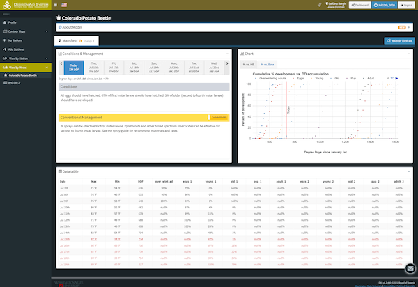
Pest phenology models
Pest pressure map
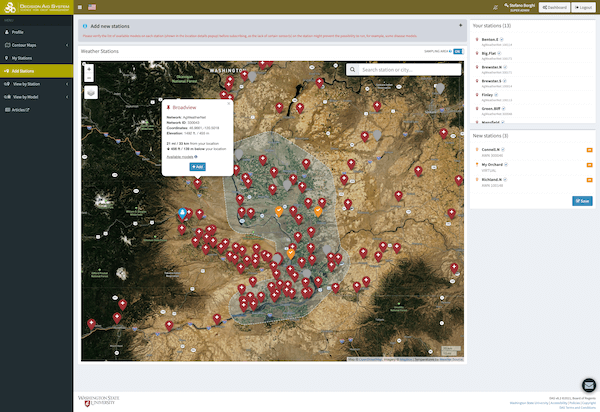
Select your stations
Mission Statement
The PNW Potato Decision Aid System (DAS) was launched in 2021 to provide time-sensitive information for
management in Washington, Idaho, and Oregon State potato crops. We are open and eager to collaborate with
scientists to integrate tools, management information, and models into DAS that will assist Pacific Northwest
potato growers make the best management decisions and remain competitive in the world economy.
Strategic Vision
The development of DAS is guided by four goals and principles:
Implement science-based tools that help with management of time-sensitive problems in entomology and other
allied sciences.
Use technology to simplify and expand our ability to provide information in a broad range of areas to
decision-makers in the potato industry.
Work with scientists to implement web and smartphone-based solutions to key technical problems faced by the
potato industry.
Collaborate with other scientists in the region to implement science-based tools for the transfer of
time-sensitive information to decision-makers. This includes sharing tools already developed by DAS or
implementing tools developed by other groups.
How It Works
Who is it for?
for pest management decision makers in the potato industry
What does it provide?
time-sensitive information on pest development, spatial tools, management options, and pesticide
considerations
accessibility on common smartphones and tablets (iOS and Android)
How does it work?
sign up for an account (currently free with ability to subscribe to 3 stations)
choose weather stations near your farm
view model output
current and forecasted status of insect pests
management recommendations depending on the pest status
access management information from the PNW Potato IPM Guidelines
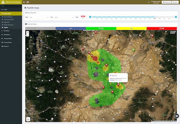
Development of the Potato Pest Mapping System
Potato growers must manage a suite of pests, including insects and diseases. Sampling networks, where pests
are monitored regularly across a broad region, allow growers to visualize “hot spots” of high pest
activity and anticipate mobile pest populations. Our team currently conducts weekly monitoring of about 50
potato fields throughout the Columbia Basin in Washington, and similar numbers of sites in Idaho, for
pests including aphids, beet leafhoppers, potato tuberworms, and potato psyllids (Fig. 1).
Figure 1
Figure 2
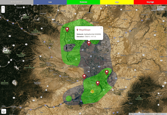
Using geographical information systems (GIS) technology and these monitoring data, we generate predictions
of pest densities across broad regions using a technique called “interpolation” (Fig. 2). This produces a
continuous prediction of insect densities throughout the region, where areas of similar pest density are
grouped together and shown on maps using the same color coding (Fig. 2).
Our predictive models are based on over 8 years of data, and are based on extensive validation. This was
done by comparing predicted pest densities from the interpolations with actual pest densities observed
through sampling. In the validation stage, we used a portion of the sampling data to develop the
interpolation models, and the rest to validate the models. We have demonstrated that our simple GIS
approach produces 60-70% congruence between predictions and observed pest densities. This is a high degree
of precision, considering that many factors (such as insecticide use) can influence pest densities.
However, it should be noted that the insect maps should be used as a guideline for what to expect, and not
a definitive count of the number of insects in any given field at any given point in time. Variability in
many factors, including grower management strategies, could cause predictions to vary from observed
counts.
Contact us if you have any questions about the pest mapping project.
PNW
Insect Management Handbook This handbook is a tool for making decisions regarding the management
of important insect pests in the PNW. For information about potato pests, select the Chapter: Irish
Potatoes.